Monday, July 27, 2009

Dawson City

July 20 -24 Spent the next few days in and around the City of Dawson. It has the most interesting history of the '98 rush to the Yukson. Dar really enjoyed this place, with all the old buildings and the "Danoja Zho Cutural Centre, where she got a pair of traditional native moccasins. Me, I enjoyed going through all the different museum's. We both took in a show at Diamond Tooth Gerties Gambling Hall and a poetry reading of "Robert Service", which was excellent. I had to have the "Sourtoe Cocktail" The toe is "for real" enjoyed but would not do it again.


By Thursday night the trailer was all repaired and ready to go, so we left Dawson first thing Friday morning.

July 24 Caught the ferry acrossed the Yukon River first thing in the morning and on our way to Chicken AK along the "Top Of The World Hwy". This 470 Km highway take you up and up to a elevation of 1260m and you actually feel like you are on top of the world. The scenery and view's are out of this world, totally beautiful. The road is what they call in "good shape." It climbs, and climbs some more. It is a all gravel road, and very dusty. (remember, no drivers window)


We got into Chicken about 3pm, was only going to stop for a wet one, but when we got to the "Downtown Chicken Saloon", what could one do but at least have two. The bar ceiling and walls are filled with business cards, hats and panties and bras that are all tattered from being shot out of a canon.


Well the throat was so dry, we ended wetting our whisle all night and stayed in their parking lot. We met a number of people from all over the place, Juneau AK, Arkansas, Louisiana,Germany and Switzerland had a great time and when the bar closed at 10pm we partied in the trailer, until 4:30 in the morning. What a way to spend your birthday, amazing.


July 25 We left Chicken about noon, neither one of us felt like driving, but made some miles. Drove the "Taylor Hwy to Tok AK and had to have a afternoon nap, and then on to Delta Junction for the night (which is at the end of the Akaska Hwy). Got up the next morning and went to the visitors centre in Delta Junction, and then on our way to Fairbanks AK.

July 27 We are staying at the "Riverview RV Campsite". Took the truck into Speedy Auto Glass, to get the drivers window installed and toured around Fairbanks for the day. In the evening we went to Fairbanks Arts Centre and saw a show of "Celebrating Athabascan People". It is a stage show with youth dancers and fiddle music and dance and some old ladies telling their stories of their lives. The music and singers share 100-year old songs in their native language, We both found it vert interesting.
Tuesday, July 21, 2009

July 21st

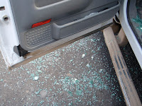
We left Inuvik Sunday morning after breakfast around 11:30am. The road out towards Tombstone Mountain Campground (where we had left the trailer at)was good and we made good time to Eagle Plains Hotel. Fueled up and had a coffee. We didn't stop and take any pictures as we were now back tracking. Not long after Eagle Plains (about two hours) a highway truck was flying towards us, traveling way to fast and as he passed us threw rocks up and literally blowing out the drivers side window. Dar was driving and she was covered in glass. I was impressed with her, I thought she handled it very well. We got to the trailer about 9:30 pm, covered in dust and cold.


Monday morning (July 20)got up and had breakfast, was just going to go outside and hook up the trailer to the truck. Then boom, the friggen trailer fell to the ground. Out we both run and there it was, the front of the trailer was on the ground. One of the front hydraulic jacks had blown a fitting causing the trailer to fall.


We spent the greater part of the morning lifting the trailer up of the ground and getting the hydraulic cylinder out the tangled mess. We had to drive into Dawson City hose fittings so I plug the hyd. lines sealed, so I could operate the system and get the slides in. We got back into Dawson City around 8!00 pm, had dinner, a couple of drinks at the "Midnight Sun" Hotel, and to to bed.We didn't even level the trailer, nor put the slides out. Tomorrow would be another day.

Good things I have friends over this country, I looked up a mechanic,who I had worked for some thirty-five years ago, in Ft St John, got the trailer to his shop by 8:30 this morning and had the hydraulic cylinder welded back into place and new fitting and ready to go by noon. Took the truck and trailer through the coin operated RV wash and into Bonanza RV Park. We did laundry today (getting rid of all the dust and mud of the last few days.) Every thing looks good again, so lets hope tomorrow will be better and we can get back to what we like doing, just having fun and sight seeing.

Sunday, July 19, 2009

Tuktoyuktuk July 18

As Dar said in the last post, I went to "Tuk" today. It was well worth it, as I enjoyed it very much.
Here are some of the pictures I took.
Here is Icehouse, which a natural Deep freese, it is 35 feet below ground level, in the permafrost


The community of "Tuk"


The MacKenzie delta, which is 60 kilometers wide, at the mouth ofthe river.


and Me at the sign


and me putting my foot in the Arctic Ocean

July 18th

Slept in till 8:00 am then went for breakfast at the Hotel. Went to the Western Arctic Regional Centre and found out where to get a flight to Tuktoyaktuk (for Brad only, small plane!). Went and checked that out and he will be going in the afternoon early evening. Drove around town and checked out some stores and Galleries. Then went back to the Visitor Centre and learned some more about the area and the people. There are about 3,500 people living here, the Gwich'in, the Inuvialuit and non-aboriginals. About 5,500 visitors come annually. There is an Igloo church "Our Lady of Victory" that took two years to build by volunteer lavour and was completed in 1960. It is 75 feet in diameter, the cross is 9' high and is 68' above ground. The copula is 20' in diamemter. Total cost in 1958 was $70,000.00.


Inuvik was concieved by the Canadian government in 1953. It was intended to replace the hamlet of Aklavik in the MAcKenzie Delta, which was subject to flooding and offered limited space for expansion. Survey parties spread over the MacKenzie Delta searching for town site locations, of 6 sites this one was chosen for its large flat area, mavigable waterway, tree cover and gravel supply. The community was first named "New Aklavik", this caused confusion for the delivery of mail and supplies, so the name "Inuvik" was selected in 1958. In Inuvialuktun it means "place of the people". In 1967 it achieved villiage status, and in 1970 it became a town with an elected mayor and council. The completion of the Dempster Hwy in 1979, Inuvik became part of the Canadian Hwy system. The land claims for the Inuvialuit was settled in 1984 and the Gwich'in claim settled in 1992.
The annual rainfall is 10.6 inches, Warmest month July, Coldest Month January, Wettest month August and Driest month February. The extreme maximum temperature is 91.04 F and the extreme minimum is -70.06 F. Inuvik enjoys 56 days of 24 hours of daylight (late June, July and early August) and has 30 days without sunlight mostly in the month of December.
Inuvik is on the east channel of the MacKenzie River Delta and 97km south of the Beafort Sea, and is 10 degrees further west than Vancouver. It is 57 square km and approx. 5% is utilized.
Permafrost
One half of Canada's land surface including most of the NWT is underlaid with permafrost, or pemanently frozen ground. It makes for bad building conditions. When the permafrost thaws, the ground shifts and building materials loose their support. It can cause walls to crack and buildings to lean dangerously. Most of the buildings and homes sit above ground on pilings, which are stilt like poles of wood or steel drilled through the active layer of the perafrost into the continuous permafrost layer beneath. In between the ground and the floor is an all-important open crawl space, to ventilate building heat away from the ground.
Pingos
are the region's most famous landforms. Currently, about 1450 are scattered across the region. Every few years a new Pingo begins to form in a recently drained lake. The sandy ground beneath a lake is unfrozen but surrounded by permafrost. Once the lake drains, the permafrost begins to spread into the unfrozen sediments as they become exposed to frigid winter temperatures. Water in the saturated sand freezes and expands, pushing excess water ahead if the freezing ground. As the circle of permafrost inches toward the centre of the lake, the excess water comes under increasing pressure. Trapped between the continuous permafrost below and the much weaker freezing crust ofthe lake bed above, the pressurized water finally pushes the lake bed up-and up and up. When the lake completely freezes, the pingo stops growing. Ibyuk Pingo is probably the world's largest growing Pingo and is just south of Tuktoyuktuk. It is growing about 2 cm per year, indicating that the basin is not frozen through yet, even though the Pingo is probably more than 1,000 years old. Most Pingos have a large crack across their summits where the ground has split apart s it is forced up from below. If the crack looks fresh, the pingo is likely growing, but if healthy willows have established themselves in it, growth may have stopped.

Dempster Hwy Map

Saturday, July 18, 2009

July 16th & 17th

Left Carmacks and heading towards Dawson City. About 40km before is the Dempster Hwy which was finished in 1979 and connected the far North and Hwy 2. Brad worked a little on the Dempster up by Eagle Plains in the 70's. 71 km in on the Dempster we parked the RV at Tombstone Campground and spent the night. The next day we took off for Inuvik. I drove for the first 4.5 hours and we saw a moose and her baby (only picture of the mom, baby in the bushes). Also a purple mountain. It is from the fireweed (the yukon state flower) that grows after there is a fire and not much else will grow.


We arrived at Eagle Plains aprox. 2:15pm and had a snack at the restaurant and then Brad picked up the driving. It is an amazing sight the whole way up here. It is so vast and empty it's hard to take it all in.


We crossed two rivers on Ferries and as you get past the last mountain range it just opens up and flatens out. We stopped briefly at the Arctic Circle to take a picture and read the signs.


It took another 7.5 hours of Brad driving to get to Inuvik. Happy to get here so we went and had a drink at the bar in our Hotel. MacKenzie Hotel of course.

Check out youtube bradanddar for a couple of short clips of the land, it doesn't really capture it but it gives you an idea.

July 15th

Today, we decided to something different, we unloaded the bike and went for 250 km ride on the motorcycle into Mayo and further on to Keno City, YK.

The first 55 km’s were asphalt, into Mayo and from there into Elsa and Keno City. It was all gravel. The gravel section had calcium on the road, to keep the dust down. They mix it with water and spray it on the roadway. You should have seen the bike, by the time we got back to Stewart Crossing. Dar and the back end of the bike were covered in caked mud.
A good shower, to both of then, and they looked fine again.

All three of these locations were past Gold, Silver, Lead and Zinc Mines, from a period the early 1920’s, up until the late 1990’s. The Highway, (Hwy 11), is known as the Silver Trail. There was more Silver taken out of this area, than anywhere else in the world.

Tuesday, July 14, 2009

July 14th

G-Day, to all, what a beautiful world we live in. This country is gorgeous!

Today we took a side trip from Carmacks,YK. First thing this morning, we did the Tage Cho Hudan Interetive Center, The centre is home to some very unique items and displays. The theme of the centre is the lifestyle, past and present of the Little Salmon/Carmacks First Nation Northern Tutchone people. It was all done very well. Gary, you would have enjoyed it yourself, way better than the at Juneau AK. Some great pictures of the exhibits. (Which you will all have to wait for until we post them on Picasa).

Then we were off up the Campbell Highway (Yukon #4) to Faro and Ross River, about a 500km round trip. The road was about 60% asphalt and 40% gravel, even the gravel sections were good. We went past Frenchman and Little Salmon Lakes, which are in the Pelly Mountains, and then on to Dorry Creek Campsite, where we had lunch.
We crossed the Pelly River, into the town of Faro, YK. We toured around town and visited the Interpretive Centre, to get a run-down on the towns future. After an assessment of remaining mineral reserves, the governments agreed that the Mine Complex would not reopen and that permanent long-term closure plan would be done.
On the way to Ross River, we saw the Lapie River,


In Ross River there is still some small time mining going on. Not much of a place, more of a location with a scattering house and a couple businesses. We went down the Pelly River ferry crossing and tooks some pictures of the Suspension bridge.


It is cable and wood bridge, and is the longest suspension bridge in the Yukon. This "bridge" carried the pipeline across the Pelly River, when it was built during the Second World War.(Google "Canol Pipeline")


Left Ross River, back to Carmacks for dinner, what a great day.

Monday, July 13, 2009

July 11th, 12th, 13th

Today heading for Whitehorse. (Have to get the tire fixed)!
Whitehorse


Made it to Fireweed R.V. Services ltd. in Whitehorse. Very nice owner said we could stay there with water and electricity till Monday morning when they could start work on the RV tire. So we went for a nice dinner at Klondike Rib and Salmon BBQ, Brad had the Muskox stroganoff and I had the Artic Char with sundried tomatoes +. Sunday we toured the city and went to a lot of museums. Found Starbuck's it's been awhile, Yummy! Monday morning David Robertson the owner of Fireweed RV, took a look to get started and saw we had another flat tire on the same side as the first one 5 days before.


As it turns out we had two cracked rims and one tire gone. Found rims at one store and got Fountain Tire to put the tires on them. They were great, put them on right away. Took the tires back to Fireweed and they put new studs in the one hub (one was bent) and put the tires back on. Can't say enough about this great RV shop! Professional, Friendly, Reasonable it made the pain $$$ a little easier to take.
On our way by 3:30pm and stopped to see the Conair guys in Carmacks (out of Whitehorse base). They seemed surprised when we drove up. Had a short chat with them and then went to find campground and have dinner. Saw them fly overhead going back to Whitehorse base.
Went for a drive around Carmacks, following the brochure that says Walking Tour (Very nice brochure). It's a dive! all the places to see were overgrown and run down. WE DON'T RECOMMEND THIS STOP! Tomorrow we are going into Faro for the day.

Sunday, July 12, 2009

July 10th

Onwards to Watson Lake, YK. Here is a picture of the lake , and the sign villiage, where everyone puts up signs from their hometown or makes a sign with their name and date they were here. it’s enormous there are 65,000 + signs from all around the world.
Not much else to tell here, had to leave early the next day to get to Whitehorse so we can get the tire fixed.

July 9th

Woke in the morning to a flat tire on the RV.
I spent an hour trying to pump up and then changing the tire. Will have to wait to hit a big town to get fixed. Somewhere I hit a good pothole and cracked the rim (didn’t know that at the time).


Over the Lower Liard Suspension Bridge (Dar driving), a 1143 foot suspension bridge (look for video on youtube).


Early day into Liard Hotsprings. I went in both pools, top one not busy, bottom one very busy. Mosquitoes were atrocious around all that warm water!


Very nice Campgrounds here. Figured out it’s better to have Dar put the RV into campsites while I direct, less fighting.

July 8th

On the road again heading North and nice to be on asphalt. Stoped at Steamboat Café (closed now) at Steamboat Mountain Historical milepost 351, then on to Tetsa River Campground and bought a homemade cinnamon bun and loaf of bread as the Milepost travel planner says this is a favorite stop. On to Summit Lake Provincial Campsite for lunch.


Saw Stone Sheep and Cariboo on our way to Muncho Lake, BC to stay the night.


Breath taking Muncho Lake.

July 6th & 7th - Fort Nelson

Finally back onto asphalt, into Fort Nelson today and the first thing I had to do was take the truck and RV to the Truck Wash. A costly bath and one hour of work. Stayed two nights at the Westend Campground in Fort Nelson. We spent an interesting 2 hours at the Fort Nelson Heritage Museum. The curator (Marl Brown) certainly has a fine collection of Alaska Hwy construction memoribilla and cars. Fort Nelson Heritage Museum
Went to the Grocery store to buy milk and bread and wound up having to go get the truck to load the Groceries home, well stocked up on food again for our travels North. Went for a nice motorcycle ride around town and out the Hwy, stopped at Trappers Den which had Furs, Books, Crafts a bit of everything.

Tuesday, July 7, 2009

Videos

You can see some short clips from our trip if you search bradanddar on youtube.

Monday, July 6, 2009

The Nahanni

I FINALLY MADE IT!!!! "THE NAHANNI", After nearly forty years of reading all I could find and watching television programs, me and Dar got the opportunity to fly into the Nahanni National Park.
The Nahanni National Park is a UNESCO World Heritage Site.It has canyons that are 3,000 feet high, a waterfall that is twice as high as Niagara Falls, hot springs and an amazing terraced calcium deposit, a gigantic whirlpool, incredible wildlife, caves that hold fossils from eons ago and unusual karst typography. The river and the surrounding area also has a fascinating history which has resulted in an intriguing mythology with place names such as Headless Valley, Funeral (mountain) Range and the Cirque of the Unclimbables…. It truly is a wonder of the world - not just a Canadian wonder.
The tranquility is inspiring. The silence is broken only by the river and by wildlife. Sadly it is too remote for frequent visits but the remoteness is what ensures the serenity will survive.
This opportunity will no doubt be with me for the rest of my Life, it was truly that heartfelt. It was that over-whelming.
FUNERAL RANGE AND SOUTH NAHANNI RIVER


VIRGINIA FALLS


BRAD AT THE TOP OF THE FALLS


THE RAM PLATEAU


LITTLE DOCTOR LAKE


Since our last post, we have traveled to Yellowknife (by motorcycle), stayed overnight at the Executive Inn Suites and back to Ft. Providence the next day. We really enjoyed ourselves in Yellowknife, saw all of the interesting sites of the city and lunch at the "Wildcat Cafe."


On June 30th we left Ft Providence en route to Fortt Simpson NWT, what a day that was, rain the whole way. I think I pushed two inches of mud virtually the whole way. You couldn't even tell what colour the truck and 5th wheel were.


On the way we stopped at Sambaa Deh Falls,


and at Jean Marie River turnoff we had lunch. On to Checkpoint and down to the ferry (crossing the Laird River) and into Fort Simpson, by late afternoon. Got setup in Fort Simpson Territorial Park and spent the evening with the rain and bomber size mosquitoes.


July 1st (Canada Day), had a fantastic time watching the local Canada Day Parade and BBQ. (good way to meet a number of local citizens). AND THEN WE WAITED, for four days until the rain stopped,s o we could get a plane into the Nahanni on Saturday.


Sunday, July 5, left Fort Simpson and on to Fort Liard. We had lunch at Blackstone Terr. Park and had the Park Attendant, play his guitar and sing a song in (Slavey tongue). The road from Blackstone Park, to Fort Laird was extremely rough. A lot of the way we couldn't do more than 20 km per hour. We stopped in Fort Liard for dinner, I had a Buffalo Burger. Dar bought some really nice Native Crafts that are made by local Dene women at the Tourist Info Place. We "dry camped" for the night, just inside the BC border.
MOOSE HIDE CC WALLET W/BEADING & BIRCH BARK CANOE

PORCUPINE QUILS AND BIRCH BARK BASKET


July 6, on to the Alaska Highway and into Ft Nelson,BC. Spent the day setting up camp at "Westend Camp Grounds" and washing the truck and 5th wheel. Wow, were they dirty.